


The first thought most people had with the avalanche of glacier and mountainside that wiped out numerous villages in Nepal was that it was triggered the 4.8 earthquake that had been felt. However, a more detailed look at the seizmology revealed a slightly larger 5.2 shaking, and along with that detailed look came the surprise that the quake was not underground. It happened right at ground level. That meant this was not a crack in a deep fault line that gave way to an earthquake that then shook ice and rock off of a nearby mountain. It was a sudden jolt that happened when something massive hit the ground—something so large that it shook the mountains around it.
Since an enormous volume of ice and water, turning to mud mixed with car-sized boulders flowed down and hit the mountain villages below, the next hypothesis was that a hanging glacier had broken loose, knocking a lot of rock off the mountainside as it tumbled. Once the area of the break was observed by air and satellite, however, it became clear that it wasn’t that big of a glacier, and only a relatively small section of it slid.
The initial fall of the glacial ice was a nearly one-mile plunge that sloped over a length of about a mile, so it was a very steep drop that then turned and fell another four miles or so into a river valley below. So it certainly could deliver a shock to the valley floor when it hit. However, where did that enormous volume of water come from?
There was not a lot of flow in the rivers of the area prior to the quake, yet the eventual wall of water that ran down the valley was massive and continued to flow at a high rate for a long time. Was there a glacial lake above the glacier that gave way—so that an ice dam in the glacier broke and the lake and glacial ice suddenly all flowed off the mountain into the river valley that ran crossways to the glacier. The answer, again, was, “No.” There was no evidence of a glacial lake above where the terminal edge of the glacier broke off. Nor was there enough ice in that much glacier for a nearly instantaneous pulverizing of the ice into water. Nor heat like there would be in a volcanic blast that would pulverize and melt glacial ice into a lahar. There was no volcano involved.
And, so, the next hypothesis was that the glacier and the rock that slide down with it must have formed a dam when it hit the valley floor, which blocked the river that flowed perpendicular to the glacier’s plunge off the mountain. The dam then held back the river’s water until enough water accumulated behind the dam of crushed ice and rubble of broken stone to create enough pressure to burst the dam.
The earthquake was believed, therefore, to be not the moment things broke loose but the massive crash that occurred when the glacier exited its trough down the moutain, and slammed into the floor of the river valley below in a large enough collision to dam the larger river valley. In the video I present below (which is kind of long and slow because it is a teaching video by a geologist), the dam hypothesis is borne out by his calculation of time between the major seismic shake and the time when the first wall of mud and water and ice struck the large ornate border crossing structure seen in many of the videos of that dramatic moment when the lahar-like flow almost instantly engulfed the Chinese-Nepal structure, which was built over the river as a bridge to Chinese Tibet.
Almost two hours elapsed between the quake and the wipeout of that first major structure, but the time it would normally take for a liquid ice and mud flow to get that far down the river with its particular geology the professor calculated to be about ten minutes. Why was there nearly a two hour delay between the glacier’s collapse yet no warning signs coming down the river the inhabited area below? Why did the initial avalance hit with such a huge thud that it shook the surrounding mountains, and why did ALL of it apparently stop right there in its tracks? No increase of muddy water came running down the river during those hours to indicate something had happened. One would think there would be smaller amounts of mud and river water that made it down the main river before enough built up to create a dam. That would have alerted villages below if the dam occurred two hours before the arrival of the larger flow. Why didn’t some of the loose ice and water and crumbled stone bend around the corner when it hit the first valley floor and flow on down the river if the glacier broke off and was leading the way down, scouring the rock off as it went?
In the video, the professor shows that the glacial ice, when it collapsed took a lot of surrounding stone with it. In fact, it dragged down a major piece of the mountain. There is a small peak beside the glacier that formed a foothold for the glacier keeping it from sliding off the mountain where rock broke away.
My hypothesis
I’m going to dive a little deeper into this event than the professor did and show you what I think the initial event was. It wasn’t the crashing of a hanging glacier. It was something so much more rare and so much bigger than a falling glacier that no one seems to be quite grasping what happened.
Photos reveal the entire mountain peak at the base of the glacier went down with the glacier. I believe the small mountain peak broke of first. Since it was was the foothold of the glacier with lots of ice pressure pushing against it, the glacier slid when the entire peak broke off. Since the peak started the fall ahead of the ice, the entire peak slammed into the valley below, creating a dam almost instantly.
Let’s explore that together with some images I’ve extracted from videos. Here is an overview of the total glacier taken by satellite before the event, which I extracted from the professor’s video:
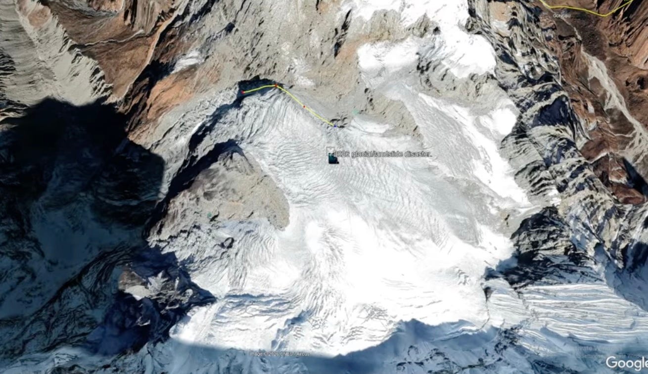
You can see the glacier rests on a broad shelf at the base of a larger peak that lines the bottom of the photo while a rocky arm descending from the peak embraces the glacier along the right edge of the photo. The wide glacier narrows as it flows toward the top left of the photo to get around a triangular area of rock that blocks its path. with rises to form a small triangular peak. As the glacier goes around the small peak, it forms an ice falls that hangs over the end of a deep ravine that exits out the top left corner of the photo.
Look closely, and you can see a thin yellow line where the professor marks the furthest extent of the glacier before it bends and hangs over the edge of cliff. The gray above that line is eroded rock, not ice. The gray below it is ice covered with fallen rock debris. This photo shows the glacier as it was before the incident. You can see the glacier turns and falls down into a steep ravine that is also gray because so much ice over the years has tumbled down there that it has eroded the sides of the ravine that is lined with a flank of eroded material from the cliffs above. It has eroded down through that material and angles out of the picture toward the top, left corner of the image. The river valley where the dam occurred is actually some distance below that top left corner. The initial drop into that ravine is almost a mile. Then four more miles to hit the river valley. So there is lots of steepness and length of the initial plunge to grind up ice and stone.
Notice that behind the flow of dirty ice as it approaches the glacial falls, the larger area of glacier presents no evidence of a glacial lake held back by the obstruction at the falls anywhere within the glacial cirque of the mountain. What I want you to really notice is the obstruction, itself, that holds the glacier back—the peak peak that I’ve circled in red in the duplicate image below:
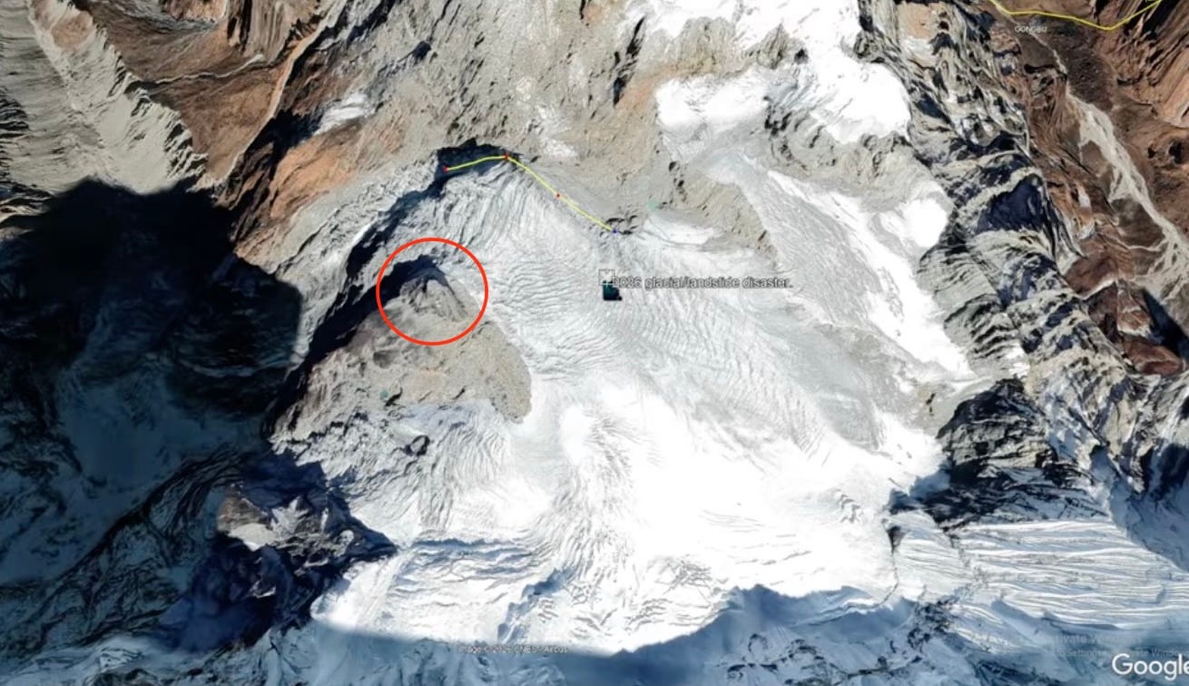
You can tell by the shadow to its left of that peak that one side was a steep cliff into the end of the ravine. I believe that the entire peak broke off, which allowed some of the glacier trapped to its right and all of the icefalls just above it in the photo to all slide down into the river valley once that peak, which was an obstacle holding back the main body of the glacier, broke off.
Of course a PEAK breaking off and falling as a whole enormous rock down into a valley is so rare it is not the first thought that comes even to the mind of a geologist, but it does explain the entire sequence of events, including the severity of the sudden quake two hours prior to the deluge, and it does fit perfectly with the aerial photo of the area taken after the event, which shows the peak NO LONGER THERE AT ALL.
Now, I’ll dig into the evidence that takes us there:
In this first photo, which is a closer view from the same angle, you can see the line of travel this glacier normally takes, as delineated with a centerline of flow by an actual geologist. You an see the flow of ice gets shouldered off the edge of that peak goes AROUND the peak, which means it also presses hard against the peak because ice doesn’t bend very easily:
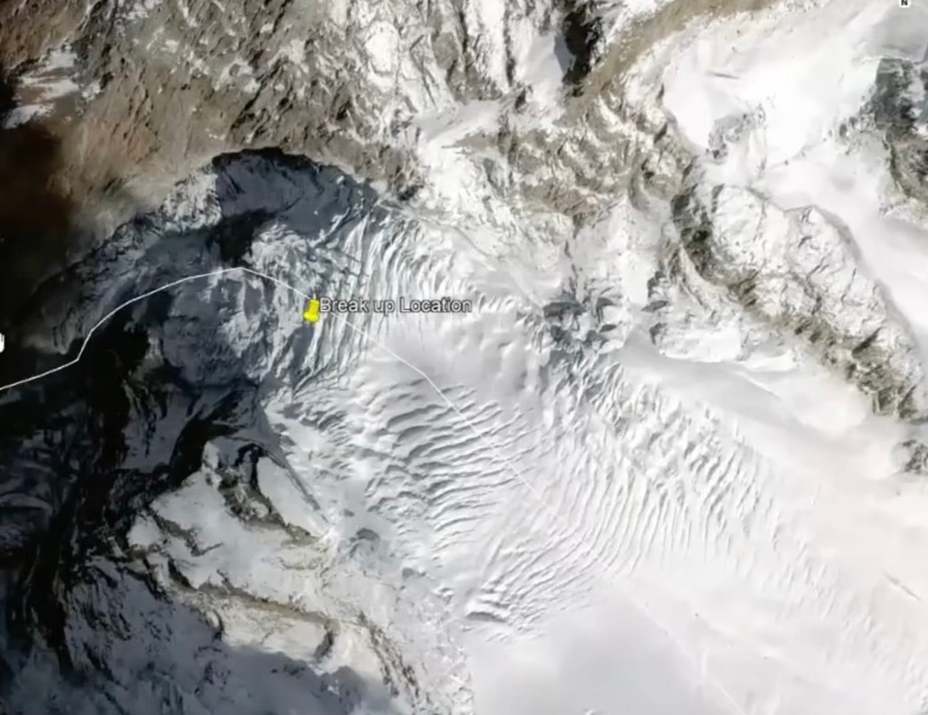
The yellow pin marks the center of the section of glacier that broke off. You can see the peak just below it. (Not “below” in the sense of elevation but below the yellow marker’s location in the photo. The peak is higher in elevation, but oriented below in the satelite photo.) At one time, the glacier was much thicker and pressed harder further up the triangular peak than it does today.
Now, I want you to look at an image that the professor in the video I present below shows of this same area BEFORE and AFTER the big event. Notice the peak, which is the dark triangular area in the left image, is gone completely in the right image—completely wiped off the moutain—and notice the escarpment in the glacier where part of the glacier is also gone.
Here is the BEFORE and AFTER:
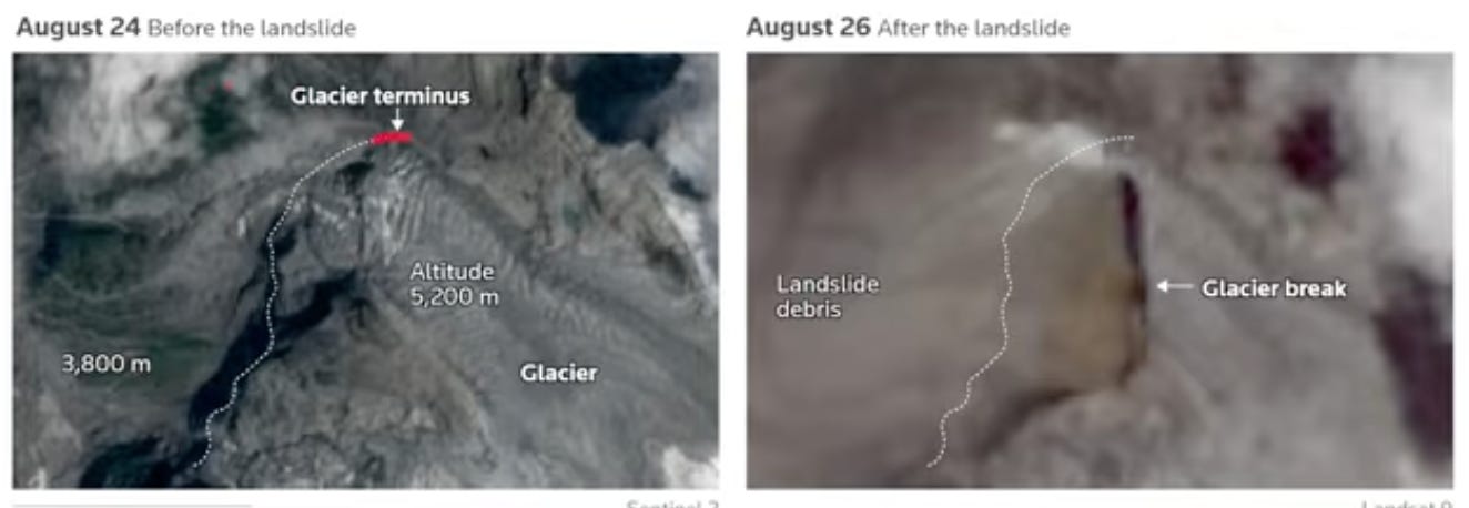
The thin white line, which is hand drawn in by the professor, marks the original extreme age of the glacier and the adjacent peak. The peak has slid in its entirety off the top of this lower region of the larger mountain. While both images are blurry, you can notice a lighter colored smear of a line of material that runs at a 45-degree angle to the top of the little peak in the first photo. You can see part of that line, albeit a lot fainter in the later image, and the peak, IS COMPLETELY GONE.
Now, I’ll show you why, which is for some reason, something the professor never mentions. Maybe I’m wrong because I’m not a geologist, but I expect sometimes some events are so large and catastrophic that they don’t come first to mind even for geologists. Let’s start with his image, where he hand draws a line on the satellite photo that represents roughly where the glacier and the stone peak broke away.
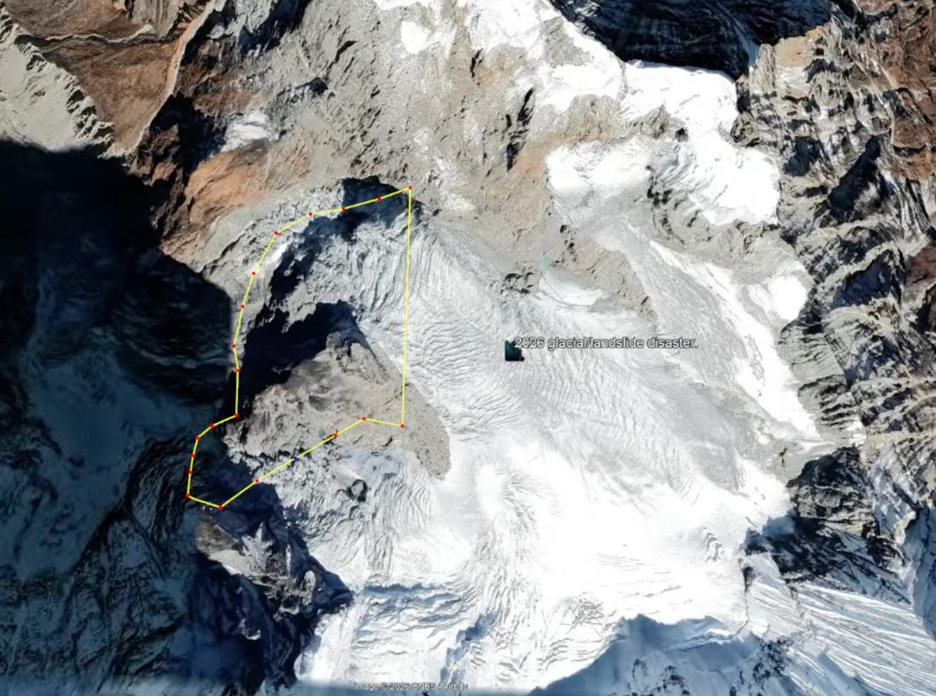
You can see now that the area that is missing includes almost all of that triangular shaped peak (even its BASE), which has just slid off the mountain. In the AFTER photo above, it is no longer there to hold back the area of ice inside the yellow line in the photo just presented. All gone. The professor says this whole thing slid when the glacier broke, but I’m going to go a little further and say that the event did not start with the glacier calving, as a number of geologists have said and as this geologist seems to be speculating, taking away such a massive piece of stone due to the movement of ice. It started with the peak breaking off the mountain and un-damming the ice that flows around it. And here is my evidence—something that shows up in closeups of the satellite photo and that follows very close to where the professor drew his estimated line, but which the professor never mentions:
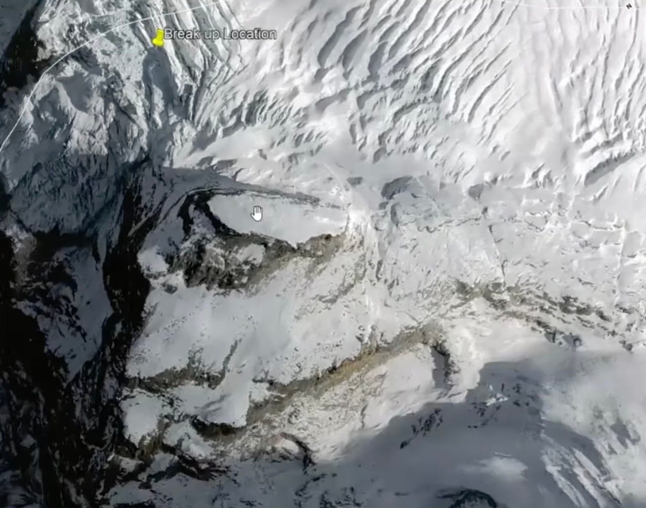
Look closely and you’ll see evidence of a number of cracks in the ice and rock that run very close to the professor’s yellow lines in the satellite photo of the area that disappeared over the edge. I’ll add lines below so you can look back up at the photo and see where the indications of cracking prior to this event are visible: (I drew the lower line just a little offset below the crack so you can see the actual large crack.)
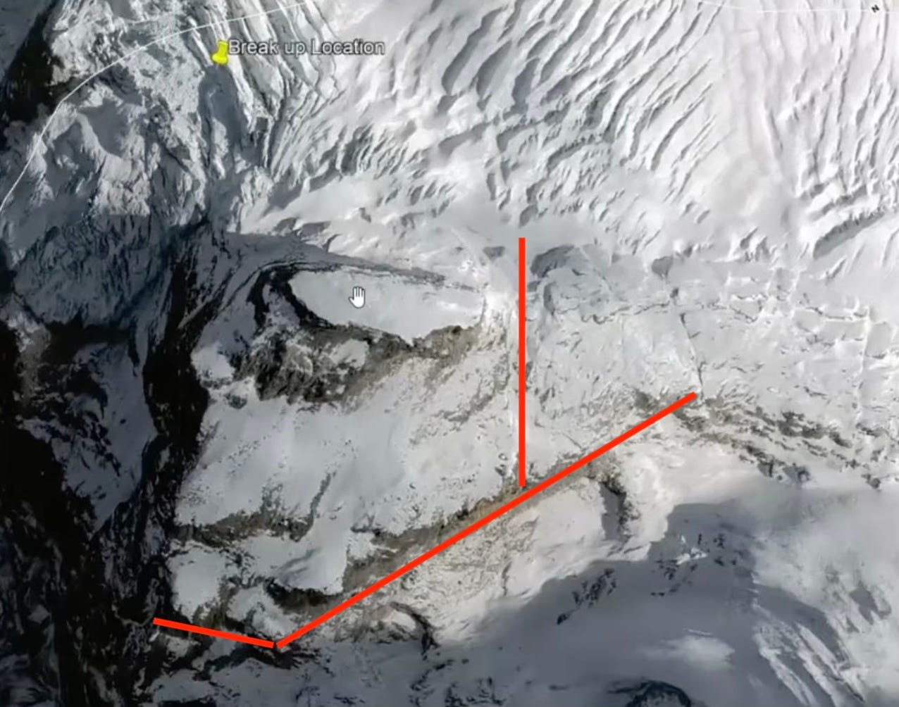
There are other cracks as well, but those red lines match up with the section that actually slid away. At the bottom there are several major cracks in the bedrock, and I picked the one that comes closest to where the final break appeared to happen, but the view angles of the photos are slightly different, so it could have been any of those cracks that change direction form the major diagonal crack. I drew the vertical line directly over the crack, but if you look at the photo above this one, you’ll see a very fine line in the ice that indicates a crack could have been there under the ice for years right where the ice actually broke off.
I think thousands of years of ice even deeper than the present age, pushing against this knob, cracked it loose from the rest of the mountain after millennia of wedging against it, and it finally slid. The professor comes close to going there, but never points out the preexisting crack lines.
The final event that pulls everything together
And here is where I think this completes the scenario. If the trigger event was the actually minor peak breaking loose the rest of the way, due to the pressure of ice for centuries around it, and sliding off the mountain, that would explain the massive quake when that entire peak slid all the way down the slope and crashed into the valley below, and it would explain why nothing flowed on down the river valley, which you can see in this image runs off to the bottom in an angle to right, perpendicular to the ravine the peak would have traveled down:
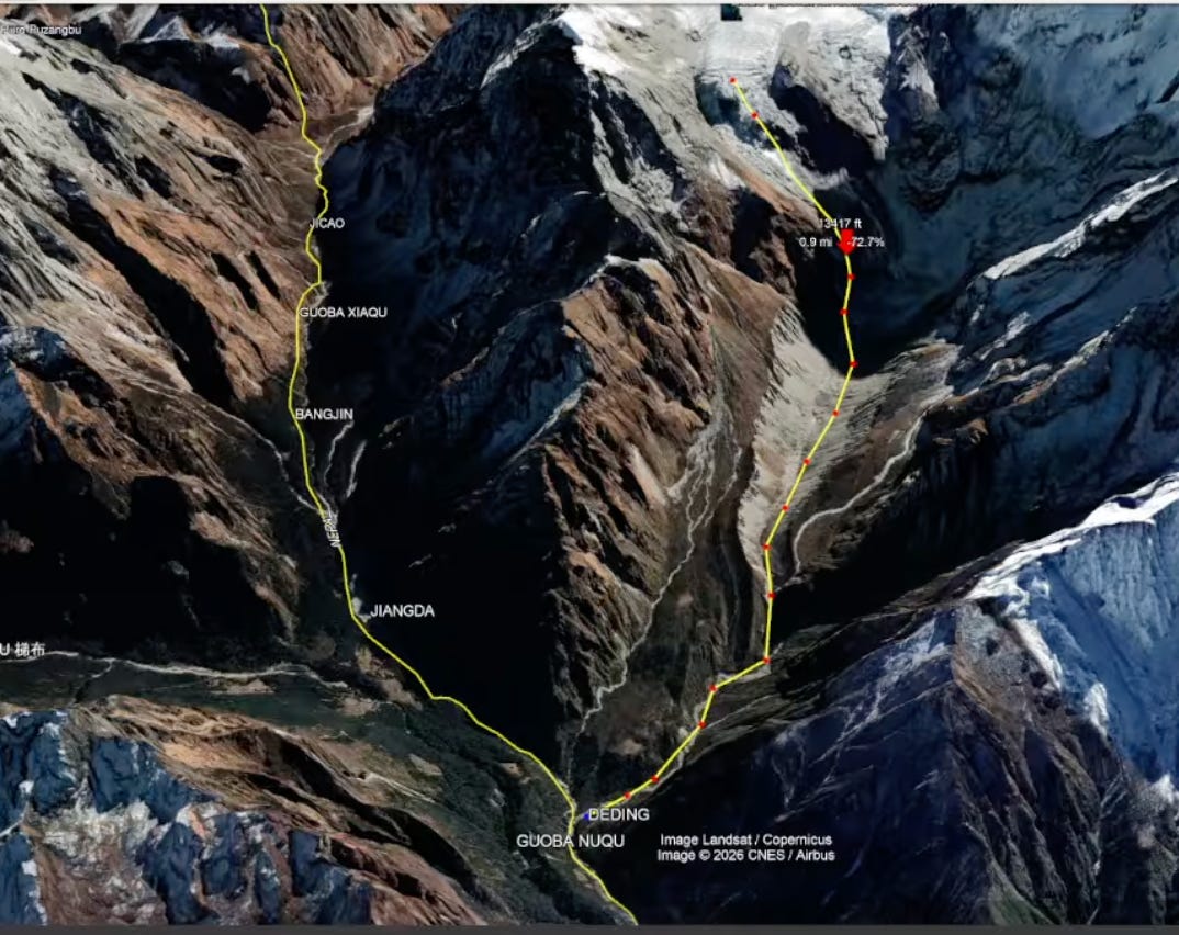
In this image taken before the event, the professor drew a yellow line with red dots, starting at the center of the glacial icefalls, and running down the center of the ravine that the glacier and rock would have travelled to get down to the river valley that it ultimately flowed down. You can see the ravine is very smooth and covered with fine debris along its sides from years of erosion that would have made it possible for the entire peak to slide down the steep, smooth ravine to the valley below as a large mass.
The peak had a sharp left turn to make once it reached the river valley, but because it was massive rock (likely breaking up some along the way) and since it broke off first, it had so much momentum compared to the glacial ice shoving down behind it that it led the fall. It had too much momentum to turn, and unlike pulverized ice, lacked the flexibility. So it drove straight across the river valley and slammed into the opposing mountain side, forming a huge plug across the river.
Using the angle of this aerial view, the ice of the glacier would have been released to slide down the left side of that path (from our perspective) when the peak gave way, and rock peak would have traveled more along the right side of that centerline since the peak in the photo is well to the right of the centerline. Again, you can see how steep the cliff was along the lower reach of that peak, leaving it so it could slide as a whole.
That means almost no ice would have landed in the valley downslope of where the mountain peak piled in. The glacier would have largely piled upstream of the dam formed by the peak (upstream being toward the top of the photo). The river that runs from the top of the photo down to this junction eventually built up enough water behind the dam, floating the ice and pressing it to dislodge some key pieces of rock and earth that suddenly allowed the whole dam structure to start sliding again down the fairly steep river to areas below what is shown in this photo to where the first damage was videoed at the Chinese border crossing.
Here is one more image where you can see the professor’s yellow line where he approximated the breakage line, and I’ve put red lines over the stony parts to the right of or below various cracks and barely visible hairline fractures, any of which could have been the actual breaking point:
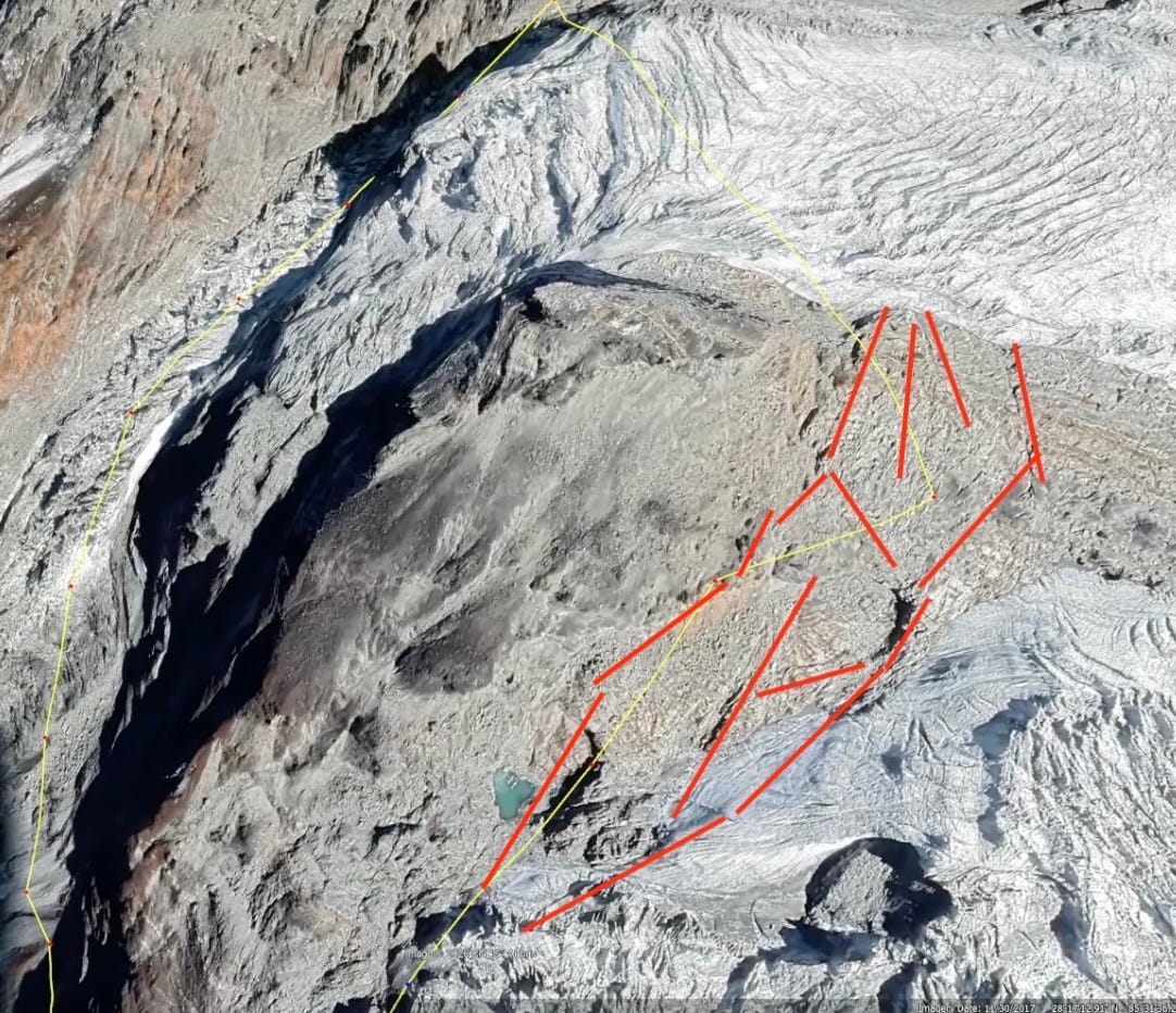
Those lines may have been there for centuries before the large piece of mountain finally gave way and slid down the slope. It’s hard to conceive of things that big; but the fact that it is no longer there tells us IT DID HAPPEN. It is just a question of which moved first, the rock or the glacier. I just say the rock broke way first and caused the ice around it to fall away because it no longer had the rock to press up against. The falling rock likely did some major ground rumbling, shaking ice loose even before its final slam into the mountainside or valley floor far below. The ice caught up and piled right behind the dam of rock and pulverized earth.
Now, here is the professor’s video. Anyone who is so inclined can watch it to see how my explanation dovetails with the professor’s to (hopefully) make full sense of all the mysteries that have been mentioned as to how this event occurred in the way that it did:
Below, for paying subscribers, are a few more excellent videos of the event. The first one is an update with many videos I hadn’t seen earlier, as well as some of the oft’ repeated videos of the cataclysm that happened all along the miles of river. Then another video explains (with some lousy fake voice) why the death toll may be far higher than anything we’ve heard. I’ve included it because I felt, myself, that the numbers officially given are way too low for the number of villages and structures wiped out in various videos for miles and miles along the main river, given the surprise by which the whole event came cascading down on people. And then a couple more collections of videos of the event.
Along with all that you’ll see some other regular headlines, such as yet another report about another major government revision down in previous jobs reports after those reports have already seen several revisions down already, proving the stealth recession to be as bad as I’ve claimed all along … once the reported numbers are finally squared up to reality.
